


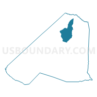
Elko Voting District, Barnwell County, South Carolina
About
Outline

Summary
| Unique Area Identifier | 665064 |
| Name | Elko Voting District |
| County | Barnwell County |
| State | South Carolina |
| Area (square miles) | 22.95 |
| Land Area (square miles) | 22.62 |
| Water Area (square miles) | 0.33 |
| % of Land Area | 98.54 |
| % of Water Area | 1.46 |
| Latitude of the Internal Point | 33.38540310 |
| Longtitude of the Internal Point | -81.35911200 |
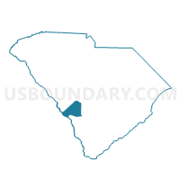
Maps

Graphs
Select a template below for downloading or customizing gragh for Elko Voting District, Barnwell County, South Carolina


Neighbors
Neighoring Voting District (by Name) Neighboring Voting District on the Map
- Barnwell No. 2 Voting District, Barnwell County, SC
- Blackville No. 1 Voting District, Barnwell County, SC
- Healing Springs Voting District, Barnwell County, SC
- Williston No. 1 Voting District, Barnwell County, SC
- Williston No. 2 Voting District, Barnwell County, SC
Top 10 Neighboring County Subdivision (by Population) Neighboring County Subdivision on the Map
Top 10 Neighboring Place (by Population) Neighboring Place on the Map
Top 10 Neighboring Unified School District (by Population) Neighboring Unified School District on the Map
- Barnwell School District 45, SC (12,382)
- Barnwell School District 29, SC (5,135)
- Barnwell School District 19, SC (5,096)